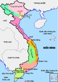
The Northern North East region comprises the Northern Delta, mountain and midland region in the North (the Eastern part of the Hoàng Liên Sơn mountain range). This region is characterized by the relatively flat terrain (the Northern Delta) and the low lying areas. In the North, there are not very high mountain ranges (1,000 m ÷ <3,000m) that lie in the fan shape in the direction of Northeast-Southwest, North-South and North Northwest-South Southeast, join together in the direction of the Tam Đảo mountain range (it is the bow of Đông Triểu, Bắc Sơn, Ngân Sơn and the Gâm river and ends with the Hoàng Liên Sơn mountain range on the border with the West of Bắc Bộ - the Northern part), creating rather than obstructing the flanks that lead the northeasterly monsoon and the northern wind during winter. This region is adjacent to the Tonkin Gulf to the East; in the West, it is shielded by the Hoàng Liên Sơn Range, the highest in Vietnam (over 3,000 m), so it is much more influenced by the ocean climate than by the climate in the Northwest of Bắc Bộ. That is why, the Eastern part of Bắc Bộ is directly influenced by the tropical storm in summer and is less influenced by the wind from Laos (the foehn wind).
The Southern climate comprises the territorial part of the Highlands and Nam Bộ (the South of Vietnam). This region has the tyupical tropical monsoon climate with two seasons: the dry and rainy seasons (from April and May to October and November). All the year round, the temperature in this region is very high. It rarely changes during the year.
The Central and the Southern Central climate comprise the territorial part of the East of the Trường Sơn mountain range, stretching from the South of the Hoành Sơn mountain range to Phan Thiết. This is the transitional climate between the aforesaid climatic regions. This region is divided into two areas:

The Northern part of the Central Vietnam is the North of Hải Vân Pass where there is sometimes the cold weather and sometimes the dry and hot weather caused by the foehn wind. In winter, due to the terrain in this region that runs along the coast of the East in the direction of Northwest-Southeast, it directly blows the monsoon in this season, also called the northeast monsoon. Shielded by the Trường Sơn mountain range in the West (by Phong Nha-Kẻ Bàng range) and in the South (by Hải Vân Pass on the Bạch Mã range) shielded in the end of the northeast monsoon. That is why, this region is influenced by the cold weather brought by the northeast monsoon accompanied by a lot of rains (especially in Thừa Thiên-Huế) due to the monsoon from the northeast direction with the vapor from the sea. So it is a bit different from the hot and dry weather of the North in the same winter.
The northeast monsoon gets weaker when it is shielded by the Bạch Mã mountain range and the Southern part is less influenced. In summer, when there is Southwesterly monsoon blowing hard from the Gulf of Thailand through to the large continent to the Trường Sơn mountain range, it pours all down on the flank of the Western Trường Sơn, but it continues to get over the mountain range to blow through this region. The typical point of this climate is that the rainy season and the dry season do not coincide with the rainy season and the dry season of the two remaining climatic regions. In summer, when there is the highest rainfall throughout the country, this climatic region is in the driest period of the year.
Vietnam’s part of the South China Sea has the oceanographic characteristics and is relatively homogeneous./.